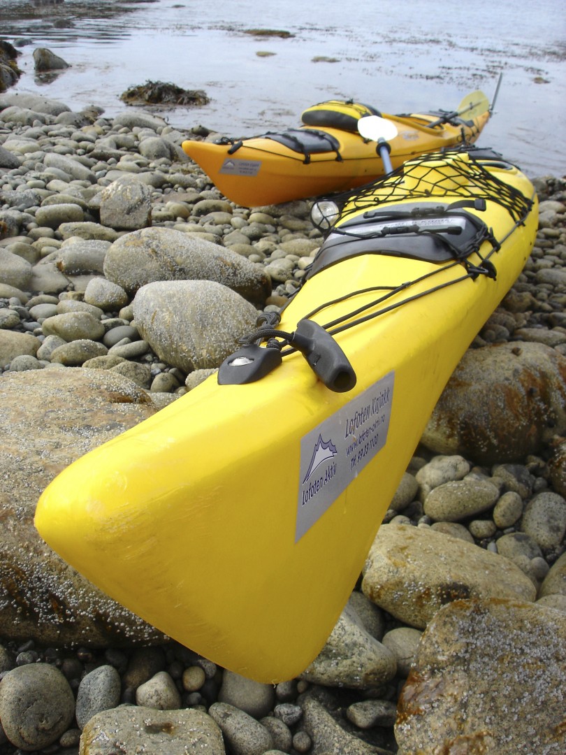
It was a sunny midnight in July as I wrestled my kayak over the ice shelf that hugged every inch of this shoreline like an Elizabethan collar.
Low tide had left an overhanging blue-white wall six feet high, dripping and dangerous. As a tried to heave myself over it, a block of ice the size of a small car cracked off nearby and crashed into the sea. I quickly clawed my way over the side. I was in search of a White-tailed Eagle, for these magnificent sea eagles breed in considerable numbers in the Lofoten Islands and I was determined to photograph them in the wild.
We had kayaked for two 10-hour days to get to this icy outpost on Værøy Island. I was hungry but too excited to eat. Besides, it didn't seem right to explore these seas on a full stomach, for this was the location of a treacherous maelstrom which was once greatly feared by sailors.
Landing the kayak in a sheltered cove beside some freshly hunted fish remains, I scanned the cliffs for the nest ledge where I knew they would build their eyrie. Suddenly, she came gliding towards me from the east like some extra-terrestrial being, dark, massive and silent as a ghost. With her great wings angled back like thick fangs, she moved against the south-westerly gale without the need of a single wing beat but with consummate ease, as if owning a secret of aerial mastery no other bird possessed. Flying low over the water, with her legs held forward and talons extended to make a kill, she swiftly turned and dropped to snatch another fish from the surface.
Viewed from the mainland across the broad expanse of Vestfjorden, the Lofoten Islands present an imposing wall of jagged peaks rising up shear from the sea. On the west these mountains form a mighty breakwater from the onslaught of the Arctic Ocean, a 112 kilometre (70 mile) archipelago which stretches from the tiny island of Røst in the south to the waters of the narrow Raftsundet in the north. In winter the coast is one of the stormiest in Europe, while the unsurpassed summer beauty of the islands makes them one of Norway's most spectacular tourist destinations.
Arctic Circle
The Lofoten Islands are located at the 68th and 69th parallels north of the Arctic Circle, a district in the province of Nordland, perhaps best known as the "Land of the Midnight Sun". Though lying within the Arctic Circle, the archipelago experiences one of the world's largest elevated temperature anomalies relative to its high latitude. Lofoten encompasses the municipalities of Vågan, Vestvågøy, Flakstad, Moskenes, Værøy and Røst. The principal islands, running from north to south, are the southern tip of Hinnøya, south Austvågøy, Gimsøy, Vestvågøy, Flakstadøya and Moskenesøya, whilst further to the south are the small and isolated islands of Værøy and Røst. The total land area amounts to 1,227 kilometres, and the current population is estimated at 24,500.
Many will argue that Hinnøya, the northern part of Austvågøy and several hundred smaller islands, skerries and rocks to the east of Austvågøy are also part of the Lofoten group. Historically the territorial definition of Lofoten has changed significantly. The principal towns in Lofoten are Leknes in Vestvågøy and Svolvær in Vågan. The islands are characterized by their mountains and peaks, sheltered inlets, stretches of seashore and large areas of virgin tundra. The highest mountain in Lofoten is Higravstinden (1,161 metres) in Austvågøy, whilst the Møysalen National Park just northeast of Lofoten has mountains reaching 1,262 metres. The famous Moskstraumen (Malstrøm) system of tidal eddies is located in western Lofoten, and is indeed the root of the term maelstrom.
Maelstrom
The maelstrom separates Moskenesøya from the small island of Værøy, beyond which is the even smaller island of Røst. Even in calm weather it seethes and boils and was made famous through the works of Jules Verne, in his 1870 adventure 20,000 Leagues Under the Sea', and Edgar Allan Poe. These are the "bird islands", which attract thousands of different species including puffin, little auk, eider duck, guillemot, razorbill, glaucous gull, kittiwake, cormorant, the endangered gyr falcon and of course, my magnificent sea eagles.
The Lofotens were the setting of a controversial invasion in the Second World War, when the islands were raided by British Combined Operations commandos during 'Operation Claymore'. The Germans had occupied Norway in April 1940, but it wasn't until a year later that the British prepared their response.
In the early hours of 4 March 1940, the first commando raid hit Svolvær, Stamsund and Henningsvær, while a second, a few months later, attacked Reine and nearby Sørvangen at the southern end of the archipelago. The first was the more successful, capturing 2,000 prisoners and destroying hundreds of barrels of herring oil, to prevent the Germans using it as a raw material in the manufacture of their explosives. However, the Germans extracted a bitter revenge by burning down the houses of all those Norwegians deemed to have been sympathetic to the raiders.
Fishing Grounds
Lofoten is Norway's prime winter fishing ground. The warming effects of the Gulf Stream draw spawning Arctic cod from the Barents Sea south to the Lofoten waters each winter, followed by migrating north coast fishermen, who for centuries have drawn most of their income from seasonal fishing. Although fish stocks have dwindled greatly in recent years, fishing continues to be Lofoten's largest industry and cod is still dried outdoors on ubiquitous wooden racks, burgeoning and odiferous in winter, empty in summer like so many abandoned climbing frames.
The annual cod run peculiar to the Lofotens in the past involved up to 6,000 boats and 30,000 fishermen. Between January and March these migrant fishermen lived in simple waterside wooden cabins called 'rorbuer'. By 1947 the number of fishermen was declining and today it is down to 2,000, and this seasonal event has been replaced by a year-round fishing fleet. Regardless, this natural phenomenon was no doubt responsible for attracting the sea eagles to these islands, for the Lofoten form the European stronghold of the species.
Vesterålen
Sharing the same history, but better known and more beautiful than their neighbours the Vesterålen, the Lofoten Islands have everything from seabird colonies in the south to beaches and fjords in the north. The traditional approach is by boat from Bodø and this brings visitors face to face with the island's most striking feature, the towering peaks of the Lofotenveggen, the 'Lofoten Wall' - an unbroken line of mountains whose jagged teeth bite into the skyline, trapping a string of tiny fishing villages tight against the shoreline. The mountains are set so close together that on first inspection there seems to be no way through, but in fact the islands are riddled with straights, sounds and fjords.
The main islands of Austvågøy, Vestvågøy, Flakstadøya and Moskenesøya are all ruggedly beautiful. Artists are attracted by Austvågøy's light and there are numerous art galleries in Svolvær, Kabelvåg and the busy fishing village of Henningsvær. Vestvågøy has Lofoten's richest farmland. Flakstadøya and Moskenesøya have sheltered bays and fjords, sheep pastures and sheer coastal mountains looming above strikingly picturesque fishing villages. Cyclists should be sure to try the unbelievable Kaiser Route, for unlike the west side of Lofoten, this trip takes in parts of the islands that are largely undiscovered by tourists, where lonely shoreline, jagged mountains and abandoned farms will be your constant companion.
Mountains
Between the mountains, which are composed of some of the oldest rocks in the world, are stretches of fertile farmland, fjords and deep ravines while the coastline is sprinkled with hamlets and one or two smaller towns.
Svolvær, the main town on the island of Austvågøy, has been a trading centre since the 17th century. Surrounded by water, and confusing to the visitor on that account, it is flanked by sharp, pointed rocky peaks. Some of these rise almost vertically from the gardens of the colourful old wooden buildings and the town has its own special mountain, the Svolværgeita ("Svolvær goat").
Museums
A compact town, Svolvær is a major hub of the Lofotens and is connected to the mainland by ferry to Skutvik, and by coastal steamer and air to Bodø. Svolvær, like the Lofotens as a whole, has attracted many artists and craftsmen and is now the site of the Nordnorsk Kunstnersentrum (North Norwegian Artists' Centre); open all year with a modest entrance charge. Scenes like those described above are captured on canvas by local artist Dagfinn Bakke who owns and runs a superb gallery here (open May-Aug), while at nearby Kabelvåg there is an art school and an impressive wooden church which looks old but was in fact built in 1898. The region is also an excellent whale-watching spot between October and December, when the Orca (killer whales) arrive in the area.
On the outskirts of Kabelvåg is the Lofotmuseet (Lofotens Museum), sited where Vågar, the first town north of the Polarsirkel (Arctic Circle), existed in the Middle Ages. In the 14th century, 80 percent of Norway's national export was stockfish, allowing Vågar a broad market and cultural exchange with the rest of Europe. The main museum building was originally in the centre of the thriving fishing community and one room is furnished as a fish station owner's office from the 1880s. He would own all the 'rorbuer' and the fishermen who rented them would pay in fish from their catches. Many of the fishing community's 'rorbuer' and 'sjøhus' (fishermen's bunkhouses) have been converted into luxurious tourist accommodation, providing a positively atmospheric sleeping option to the normal guest houses. It was my good fortune to stay in such a property upon my return from the remote island of Værøy. There is a typical 'rorbuer' from 1797, with its primitive and crowded living conditions, and a boathouse with three traditional boats of various sizes. Another building at the museum is devoted to the development of the Lofoten fishing industry, which in its modernised form plays a vital role in the economy of the islands.
Island Hopping
For those less adventurous, island hopping is relatively easy in the Lofotens , for there is also a very good road link from Narvik on the mainland. To journey south on the E10 means going from island to island, all of which, bar one, have gradually been linked by impressive bridges. The one remaining Hurtigruten ferry connection was replaced by an undersea road tunnel in 1990. This route must rank as one of the most outstanding in Norway. At every turn the traveller is confronted with another seemingly haphazard series of jagged peaks possessing a stark beauty which contrasts with the green scenery at sea level.
On the southern tip of Austvågøy is Henningsvær, one of numerous Lofoten fishing villages and home to the renowned Galleri Lofotens Hus, which exhibits (and sells) the work of the contemporary Norwegian artist Karl Erik Harr. The imposing bridge over Gimsøystraumen, 840 metres long, provides access to the small island of Gimsøya. From here a second bridge takes the road across Sundklakkstraumen to Vestvågøy. Stamsund, on a secondary road, is a coastal village and a port of call for the coastal steamer. The last bridge takes the road across the island of Moskenesøya, where the E10 finally comes to an end in the far southwest.
The Lofoten Islands have their own relaxed pace, and are perfect for a simple, uncluttered holiday with a difference. For somewhere so far north, the weather can be exceptionally mild; summer days can be spent sunbathing on the rocks or hiking and cycling around the superb coastline, and when it rains – as it frequently does – life focuses on the 'rorbuer', where freshly caught fish are cooked over wood-burning stoves, stories are told and time gently wasted.
